- - - - - - - - - - - - - - - - - - -
City Clean-Up 2025 - click here: 2025 Spring Clean-Up Flyer.pdf
Household Hazardous Waste Collection Event - click here: 2025 Household Hazardous Waste Event Flyer.pdf
Disposal of Signal Flares - click here: PSA Proper Disposal of Signal Flares 031425.pdf
Granite Creek Overburden Waste Disposal Site Location - click here: PSA-Overburden Waste Disposal Map.pdf
City and Borough of Sitka - Disposal Locations and Rates 2024-2025 - click here: CBS Disposal Locations and Rates Feb 2025.pdf
- - - - - - - - - - - - - - - - - -
Click here: Professional Services Roster 2024-2025 3-14-2025.pdf
The Public Works Department has created an interactive map that exhibits changes from the currently adopted 2010 FIRM when compared to the updated 2019 FIRM, this interactive map is accessible at this link: FEMA Flood Map Comparison
Tips for using this interactive map:
This map functions optimally when using the Google Chrome browser.
The blue “comparison slider” circle and white vertical lines attached to it defines the border between the two separate maps and can be dragged right and left to better view the differences between the separate maps.
The 2010 FIRM is shown on the left-hand side of the screen, the 2019 FIRM on the right.
Use your mouse wheel or keyboard function to zoom in and out, click and drag the screen to navigate around Sitka.
Additional details (structures, street names, address numbers) become visible as you zoom in on a specific location (Baranof and Japonski Islands only).
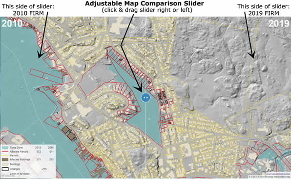
Call (907)747-1804 for assistance utilizing this map, if needed.